
Our Rivers
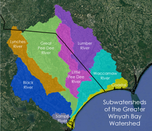
Also known as the Lower Pee Dee Basin (Hydrologic Unit Code 030402), we refer to the large watershed over which we watch as the greater Winyah Bay watershed because all rivers ultimately discharge into the Winyah Bay estuary near Georgetown, SC.
As displayed in the image, the watersheds of the Waccamaw, Lumber, Little Pee Dee, Pee Dee and Lynches originate in North Carolina and flow into South Carolina.
The rivers of the greater Winyah Bay watershed have played a major role in the history of the region through which they flow, and continue to play a role in the lives of many North and South Carolinians. These rivers provide drinking water and support commercial and recreational fisheries, hunting traditions, birding, boating and other water sports, and tourism, and enhance the lives of those who live, work, and play here.
The SC Watershed Atlas provides information on the SC portion of the Lower Pee Dee Basin (SC’s Pee Dee Basin).
Information on the NC portion of the Lower Pee Dee Basin is available at: Lumber River Basin and Yadkin River Basin.
Waccamaw River
The Waccamaw River watershed includes 1,640 square miles within North and South Carolina. Its headwaters are in North Carolina and the river originates at Lake Waccamaw, a permanently inundated Carolina Bay managed as Lake Waccamaw State Park.
The Waccamaw River is a coastal plain river with extensive wetlands that leach pigments, such as tannins, causing its dark coloration and description as a blackwater river. This blackwater river flows over 140 miles through North and South Carolina. Along the way, the Waccamaw joins with the Atlantic Intracoastal Waterway in South Carolina, then with the Great Pee Dee River before it empties into the Winyah Bay estuary at Georgetown, SC.
Thanks to our partners, including American Rivers, Pee Dee Land Trust, and many others, the entire river is designated as the Waccamaw River Blue Trail and its ~100 miles in South Carolina are additionally designated as a National Water Trail.
Through our Waccamaw RIVERKEEPER® Program, we are actively monitoring, protecting and advocating for the protection of the Waccamaw River watershed, including:
- water quality monitoring from Lake Waccamaw to Winyah Bay with dedicated volunteers
- litter cleanups through community cleanup events, including our Adopt-a-Landing groups
- advocating for watershed protections at the City, County, State and Federal levels
- protecting wetlands, floodplains, riparian and other watershed lands for the benefit of our natural and human communities
- promoting recreational opportunities that benefit our communities and our resource based economy
- and so much more!
Lumber River
The Lumber River watershed comprises 1,750 square miles within North and South Carolina. The watershed begins at the headwaters known as Drowning Creek, in the counties of Moore and Montgomery, in the Sandhills ecoregion of North Carolina. The main stem of the Lumber River lies in the Coastal Plain ecoregion with extensive wetlands that leach pigments, such as tannins, causing its dark coloration and description as a blackwater river.
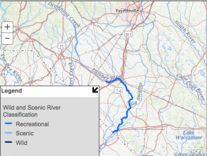
This blackwater river flows over 125 miles through North and South Carolina. All 115 miles of the Lumber River in North Carolina are designated a state Natural and Scenic River. Of these, 81 miles are also designated as a National Wild and Scenic River. The river crosses the South Carolina border downstream of Fair Bluff, NC and ~10 miles downstream of the SC border, the Lumber River joins the Little Pee Dee River.
A dedicated friend of the Lumber River, Dr. Colin Osborne, III, has written about the Lumber River – Nature’s Sanctuary. Dr. Osborne writes:
“At a moment in the nation’s history when many people valued natural resources more for their commercial than for their recreational, ecological, or esthetic values, citizens along the Lumber River joined together to protect this historic waterway. How the Lumber River State Park came to be is a mini-epic chronicling the efforts of a diverse group of recreationalists, conservationists, and naturalists in North & South Carolina. Their work also resulted in the designation of the Lumber River as a Federal Wild and Scenic River, the first black-water river to receive such status in the Eastern United States. That was the most consequential river preservation effort of the late 20th century in southeastern NC.“
Through our Lumber RIVERKEEPER® Program, we are actively monitoring, protecting and advocating for the protection of the Lumber River watershed, including:
- holding polluters accountable for impacts to our river and the communities that rely on it
- engaging environmental justice communities in decision-making that impacts protection of clean water and our quality of life
- promoting community engagement and volunteerism in river stewardship, including water quality monitoring and litter cleanups
- promoting recreational opportunities that support our community and our resource based economy
- and so much more!
American Rivers named the Lumber River One of America’s Most Endangered Rivers® of 2026. https://www.americanrivers.org/media-item/forever-chemical-pollution-lands-lumber-river-as-4-americas-most-endangered-rivers-list-of-2026/
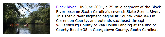
Black River
The Black River is a free flowing blackwater river, traveling ~151 miles before merging with the Great Pee Dee River in Georgetown County. The Black River Basin is located in Kershaw, Lee, Sumter, Clarendon, Florence, Williamsburg, and Georgetown Counties, and encompasses 2,061 square miles with geographic regions extending from the Sandhills to the Upper and Lower Coastal Plains and into the Coastal Zone.
Scroll down for information on our Black-Sampit RIVERKEEPER® Program.
Sampit River
The Sampit River is a small, 165 square mile, but important watershed, located entirely in Georgetown County, flowing from wetlands in the western portion of the County ~11 miles to join with the Black, Great Pee Dee and Waccamaw Rivers, flowing into Winyah Bay and ultimately the Atlantic Ocean.
Historically the site of extensive rice cultivation, it has a rich Gullah-Geechee heritage. Now, home to a mix of industries, recreational sites, and the City of Georgetown, the Sampit River provides many services to its communities and the local economy.
Through our Black-Sampit RIVERKEEPER® Program, we are actively monitoring, protecting and advocating for the protection of the Black and Sampit River watersheds, including:
- water quality monitoring with dedicated volunteers
- litter cleanups through community cleanup events, including our Adopt-a-Landing groups
- advocating for wetland, floodplain, and riparian protections
- planning for conservation and recreation along the Black River, including Rocky Point Community Forest, the Black River Water Trail and the State Park Network
- and so much more!
While we do not have an official Riverkeeper program specific to our Pee Dee Rivers (Little Pee Dee, Pee Dee, and Lynches Rivers), our Pee Dee Rivers/Lynches River Project Coordinator is watching over these watersheds, with an emphasis currently on water quality monitoring and litter cleanups.
Our goal is to expand our programs in these three watersheds in the coming years.
Little Pee Dee River
The Little Pee Dee River is a 116-mile-long tributary of the Pee Dee River. The Little Pee Dee technically arises near Laurinburg, North Carolina as Gum Swamp, which flows southward, receiving several small tributaries, across the South Carolina border into Red Bluff Lake, near McColl, South Carolina, then flows to the Pee Dee River and eventually drains to Winyah Bay.
American Rivers named the Little Pee Dee River One of America’s Most Endangered Rivers® of 2024 https://www.americanrivers.org/media-item/little-pee-dee-river-named-one-of-americas-most-endangered-rivers-of-2024/
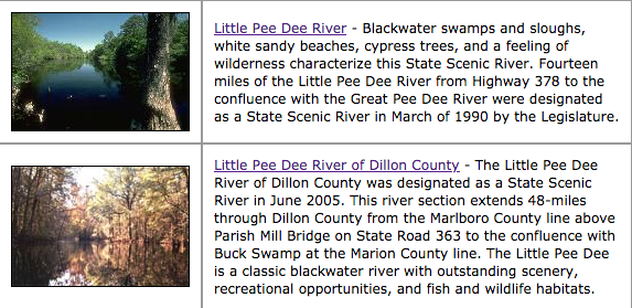
Little Pee Dee Scenic River – two sections are designated
Pee Dee River
The Pee Dee River is part of the Yadkin-Pee Dee River Basin, starting as the Yadkin River in the Blue Ridge Mountains and flowing for approximately 200 miles before it becomes known as the Pee Dee River, then another approximately 230 miles southeastward into South Carolina where it becomes known as the Great Pee Dee River, into which the Little Pee Dee River flows, and eventually joining the Waccamaw River before draining into Winyah Bay.
Unlike the other rivers we watch over, the Pee Dee River is a brownwater river, carrying sediments that cause the color to appear “brownish” as compared to the black water of our other rivers. It originates in the Appalachian Mountains and descends through the Carolinas to the floodplains of South Carolina extensively developed for rice culture in the past.
The portion within the greater Winyah Bay watershed begins immediately downstream of Blewett Falls Lake in North Carolina flowing to Winyah Bay.
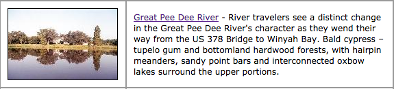
The lower 70 mile stretch is designated the Pee Dee Scenic River.
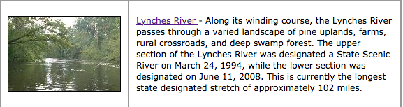
Lynches River
With its headwaters just across the border in North Carolina, the Lynches River flows for ~175 miles southeasterly until its confluence with the Great Pee Dee River near Johnsonville, SC. Along the way, it passes through pine uplands, farms and deep swamp forests.
Citizen Engagement
If these important rivers are to be protected, citizen activists must become involved!
Help us protect our local rivers.